SUTD study uncovers how China’s dams are operated along the Lancang-Mekong river
SUTD - Dung Trung Vu, Thanh Duc Dang, Stefano Galelli
USF - Thanh Duc Dang
UW - Faisal Hossain
Detailed knowledge about water release decisions from big hydropower dams allows for more effective transboundary water management efforts.
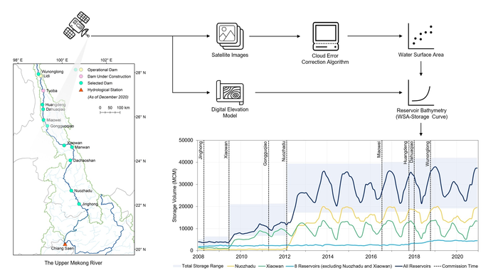 An overview of the study areas, applied approaches, and results of the reservoir storage.
China’s dams along the Upper Mekong, or Lancang, are often blamed as the main cause of recent droughts in the downstream regions. Yet, it is challenging to corroborate these claims, since China has not been releasing detailed data on how its big dams in the Lancang are operated. Using data from satellite images and high-resolution hydrological models, researchers have finally solved the enigma.
The study, titled ‘Satellite observations reveal 13 years of reservoir filling strategies, operating rules, and hydrological alterations in the Upper Mekong River basin’, was published in the journal Hydrology and Earth System Sciences by researchers from the Singapore University of Technology and Design (SUTD), the University of South Florida, and the University of Washington.
The research team estimated how much water was stored and released on a monthly basis by each dam during the past decade. “Knowledge about these management decisions is very important for downstream countries,” explained corresponding author of the study, Dr Stefano Galelli from SUTD. “The Laotian hydropower industry, for example, could use these data to better support its operations, particularly during droughts. Another key economic sector that could use these data is rice farming in Cambodia and Vietnam.”
Data show that the 11 dams built on the main stem of the Mekong have a total storage capacity of about 42 km3, about 55% of the annual river discharge in Northern Thailand and Laos. Their storage fluctuates on an annual basis, following the succession of dry and wet seasons that is typical of the Monsoon Zone. This is where things get interesting: the analysis indicates that dam operations did not change during the 2019-2020 drought that affected the region. “We have wondered if emergency releases from these dams could have helped mitigate the drought impact,” added Dr Galelli.
The researchers also uncovered the dam filling strategies—the decisions made to fill in new reservoirs to the minimum storage required for operational purposes. They found that the two largest dams, Xiaowan and Nuozhadu, which were built in 2009 and 2012 respectively, reached steady-state operations in about two years by retaining 15% to 23% of the annual inflow volume.
“Uncovering dam filling patterns provides additional information that is very vital, since another 65 km3 of new reservoir storage is planned for the Lancang,” explained Dung Trung Vu, the lead author and PhD student from SUTD. “Knowledge about filling strategies can help downstream countries prepare for temporary water scarcity,” he added.
This then begs the question of what can be done to improve water management in the Mekong.
“The Mekong Riparian countries only share a small fraction of data that are needed by scientists, water managers and decision-makers,” explained Dr Galelli. “Our efforts improve on current initiatives on river basin monitoring and have the ultimate goal of supporting a more open approach to the management of Southeast Asia’s most important river basin.”
Reference:
Satellite observations reveal 13 years of reservoir filling strategies, operating rules, and hydrological alterations in the Upper Mekong River basin, Hydrology and Earth System Sciences. (DOI: 10.5194/hess-26-2345-2022)